Whew! It's been over two weeks since my last post, the reason of course being that I was off on the classic Everest Base-camp trek here in Nepal! To make a long story short, the hike was amazing, the scenery surreal, and I had a wonderful time. I can hardly wait to tell you all about it!
Upon my return however, I knew I had a big job in writing it all up; I have a process. First I take all the pictures that are new since the previous post and review them to remind myself of exactly what I'd done for those last days, then I select the ones that are of some interest to me either in the series of events or the sights around me. This always yields far too many, so then I have to narrow it down to the select few that can effectively tell the story. It has to show all the important steps, beautiful scenery is a must, local culture as well, transitions are important and it must show a real human experience.
It isn't an easy job I have assigned myself, but I do enjoy all the work. I know my audience is limited in size, but it is worth it for those who are reading, as well as being a great record for myself. I hope it can inspire others to travel or follow their dreams, and I hope it can serve as a record for anyone to see, of the beauty and promise the world holds.
For this post I began with 676 photos I took on the trip. As you can imagine, I had a lot to choose from in terms of nice ones. My first go at cutting those down gave me 178, then 110. Eventually it got down to 86, 74, 71, 67, 64 and finally 62 images. From here I look at the distilled images in order, referencing the entire batch to make sure I don't forget any important details, and begin writing. Usually it just flows out, and while never in a hurry it is steady. I usually write them in a single sitting. The later in the trip, the longer my posts seem to have gotten, I hope it's not too long, I guess I'm just doing what feels right to me and trying to get in all the details I now find important. I hardly ever proof-read it, I'm sure you can tell in places, haha. It is pretty much pure stream-of-consciousness, and that's the way I like it! Anyways, with that said, here is episode 37:

Due to my short illness the previous days and postponement of the trip by three days, I had a little more time to prep, which was not such a bad thing. I picked up a few last minute items such as candles (which I didn't use), granola bars and bandaids. I also had to pick up a large amount of cash to use on the trail. Due to the price of food out here (more food later) 1,500 rupees a day is not a bad idea, and I found I spent just that over the 13 days. I also needed to have my TIMS card, the entrance permit to the park, and my air ticket to fly from Kathmandu to Lukla where I will begin the trail. These cost me about $300, and between that, the clothing I bought, and the money I spent on the trail, this outing has been the most expensive thing by far on my 6 month trip. But it's worth it. I had a relaxing day really, and went out for some music and one last solid meal before hitting the trail.

My flight was scheduled for 8:30am, but Birendra who organized all my details for me recommended I get to the airport by 7am and try to catch an earlier flight. I took an early taxi to the airport and no one seemed to want to talk to me about an earlier flight. On top of that, it was delayed and we didn't take off until 9:45am, but it wasn't really a big deal. From the seats of the 12 (?) passenger, double-prop plane, the smallest I've been on, we saw the flat and dry Kathmandu, then on to the terraced hills on the edges, and quickly saw snow-capped mountains. The flight is only about 40 minutes long, and the sudden change amazing.

By 10:15 the plane had landed at the Tenzing Hillary Airport in Lukla, Nepal, names of course after the first two men to summit Mt Everest. The plane practically buzzes the tops of hillsides when heading to the runway, which is on the mountainside. Lacking a long flat space like a normal airport, it instead goes straight up the mountainside, using the rather steep uphill nature of the runway to slow the plane on such a short landing. The pilot then steers the small plane the rest of the way up hill and towards the actual flat loading/unloading zone. As you can imagine, the takeoffs are even more exciting. The pilot rev’s the engines full bore while pointing downhill, then lets off the breaks, where the plane begins it's mad dash flying down the runway and off the ground before the huge cliff at the end. Zero room for failure here, folks! (I think I remember my dad telling me a story about this airport, actually)

The town of Lukla is at 2842m, and it was hot, dry and sunny day. I had some soup in town trying to take it all in (and also because I hadn't eaten breakfast yet!), then walked down the path out of town. In keeping with usual style, I didn't do a lot of research or planning, and wasn't exactly sure what to expect. I am going alone without a guide/porter/group, because I don't like the structure of those kind of programs, they cost way more, tend to be too easy/slow and this place is easy, you just don't need a guide.

I began walking, naturally, in my purple $3 flip-flops I bought way back in Cambodia and shorts. Right away you see some of the classic scenery: Buddhist images everywhere, high peaks, porters with heavy loads, yak trains and people, people, people everywhere. This thing is like a highway. I even experienced a traffic jam an hour in! I knew this place was going to be busy, but I didn't know just how many people are out here. There was never a five minute period where I was alone on the trail.

I walked to Phakding which is where many programs stop for the day, and kept going to Manjo. The recommended distances/time-frame for this hike seem so short it's absurd to me... Cherry trees and rhodies were blossoming, you walk above the river, it is all nice scenery though. In Manjo I stopped in a grubby looking tea-house, the kind I imagined my dad stopping at back in 1979 (?) before all this development. I got a tea but was told it was only a Nepali place to sleep, so I went on to a nicer looking tourist lodge.
This is a typical room on the trail, small, simple bed, and a window. The rooms tend to cost only 100 rupees, less than $1.50, and have shared squat toilets. Then there is a common dining area with a stove burning yak-poo for heat which may or may not effectively warm the place. I guess Nepali people just don’t' get cold, because they sure like leaving the doors open and letting cold air in, haha, just an observation. There were three kinds of people in the lodge, and this theme was consistent through the trip. The largest number of people are those on a package group trip with guides, often with porters. Then you have the people with or without a guide who have been to Nepal many times and are doing the hike again, then you have me, flying solo and looking for a challenge. In the common area you eat from a menu that is pretty much the same the entire trail. On if you have your eggs, rice, noodle, potato, etc dishes, and right away the prices are way more than you are used to paying. Goods have to be carried in on yaks or with porters, and obviously the lodges make all their money on the food, not the room. No big deal, but it does come as a shock when bowl of Ramen noodles costs as much as a serious meal with drink and sides in Kathmandu.

The next morning I awoke to the sounds of noisy hikers leaving with their guide, and once they had cleared out I had my breakfast and headed out on my way. It was a perfect day, and I was headed to Namche Bazar, at 3440m, the 'big town' on the trail. According to my map it was 4.5-6 hours away.
Because the trail goes up a valley, you end up crossing the river numerous times, all offering their own picturesque elements. The bridges are all these very sturdy looking and feeling cable suspension bridges, and every one of them has prayer flags attached to it. This particular picture is of the Larja Bridge, and right after it you begin the steep trail to Namche, 600 meters higher.

One of the countless porters on the trail, trying to fit his wide load through the trees. I was told porters only make 200-300 rupees a day, and when they are not part of a tour group with load limits, some will carry over 100kg on that basket hanging off their heads. You see maybe 20 porters for every yak I seems, and often it looks like the porters have the larger loads! On backs you see eggs, beer, propane tanks, plywood, everything needed farther up the trail. It's best to stay out of their way since they are working so hard, but they are always friendly and a good 'namaste' is always greeted with a smile.
A bit farther up the trail you begin to get some much better views of the mountains around you and where you are, in the Himalayas! Again, the mountains remind me of home, and I sit down to stare for a while.
I got to Namche Bazar in just over two and a half hours, and I wasn't even moving quickly... The town is pretty much just a jumble of lodges and shops for hikers. It sure has some nice views though. You have your choice of multiple bars with pool tables, dozens of internet cafes, bakeries, and tourist-trinket and gear shops selling all the same things as back in Kathmandu, but for a greatly inflated price. I picked out a lodge at random and got a good clean room, again for 100 rupees. It's so early in the day I'm trying to figure out what to do with all my time, and the guides recommend a day to acclimatize here? Sure you can do a day-hike, but I didn't want to spend more time here, I was already getting frustrated with the slow pace and crowded nature of this hike.

Also in the lodge, were two guys, Dev and Martin, who were doing the hike with a guide. We chatted for a while and decided to go to the bar next door because it was playing a movie in the afternoon. They were showing 'Into Thin Air' about an Everest climb where lots of people die. They show it EVERY DAY. The book is good, the movie is just corny. Anyways, I was getting increasingly frustrated with the hike thus far and got out my map looking for advice. I needed to get away from the crowds, the shops every twenty minutes and this slow and easy trail. I talked to some people at a shop, and they recommended I go up the Gokyo Valley and over Cho La pass, but of course tried to push the idea that I needed a guide. I decided to ditch the Hillary-Tenzing route in favor of the more challenging trail, and started to feel a lot better about the hike.

The next morning I awoke to perfectly clear skies and the sun rising on beautiful mountains out my window. Talk about a room with a view. I was headed over the hill behind Namche to Khumjung, and this steep climb took me pas the dirt airstrip, past the Everest View Hotel (where guests were arriving via helicopter) and into the town of Khumjung which felt like another world from Namches hustle.

As I was leaving Khumjung, I met Tshering Tashi Sherpa on the trail and we began to chat, as we were headed in the same direction. His family owns a lodge in Phorche, his dad has climbed Everest three times, and will go to study in America. Along the trail, we actually talked a lot of politics, many of his questions I answered with “It's complicated...” haha... He took me up the 'short-cut' on the trail, which involved some of the steepest stairs I've ever seen up the cliff. When we got to Phortse Tenga, we had tea together and helped me plan a more challenging hiking route/schedule, being amazingly helpful and friendly. Naturally, if he makes it to Seattle when he comes to study in the States, he is welcome in my home;)

With my new advice and plan I was once again thrilled to be out here, and headed off on my way. As has been a common theme on my trip, when things are not going as well as you hoped, all it takes is one friendly local to help and turn it all around. I was now off the main trail, and I was feeling great. I began climbing and while still in the trees/shrubs, came to my first bits of snow on the ground and frozen waterfalls, which of course got me excited. The rest of the day, I saw very few people on the trail, mostly porters and a few independent hikers like myself. As I was walking through the birch/rhodie forests, I saw an amazing looking blood pheasant (thanks for the ID, Brendan), past Nepalis carrying rocks and building trail, into increasingly amazing views and well above treeline.
It was just the change I needed.
I arrived in Machherma, a 'town' of about a half dozen lodges, at 4410m, already I am up higher than the summit of Mt Rainier back home, it's a funny feeling. After a good 8-hour day and 1070m rise in elevation, I finally felt tired and good. I finally took off my flip flops, washed my feet, and but my boots on for the first time. The rest of the evening was spent totally alone in the lodge (she says sometimes it has 30+) sitting next to the fire, which put out almost zero heat. Oh well. Had some tuna pasta for dinner, and went to bed early.
I don't have a very long day ahead of me, so I sleep to 7:30am, and was greeted with a light dusting of snow everywhere. It was a nice reminder of how high up you really are out here, and helped put me in the Himalayan mood. As the sun reached into the valley the show melted almost instantly, leaving the trails slightly muddy and I was glad to be wearing my boots now. I continued up the valley towards Gokyo.
Farther up the valley come upon the small series of lakes and even more stunning sights. Plants are sparse and tough, peaks are even more dramatic, and you real begin to feel like these are the real deal mountains.
The hike to Gokyo was also short and easy, and took me to 4750m. The village itself sits on the Dudh Pokhari, the '3rd lake' and at the base of more wonderful peaks. After changing into my comfortable cloths and having a tea, I walked around the area taking a few photos and spent the afternoon reading. Later in the afternoon I started to get a headache.
Oops, early sign of AMS, 'acute mountains sickness' also known as altitude sickness. I knew all about it, but here I was feeling like a total idiot, the classic case of the young fit guy who overdoes it, haha. I got to excited about the route I devised with Tshering I really didn't pay attention to the altitudes. I've seen recommendations of only 400 a day, with acclimatization days thrown in, and I sure didn't do that! I was looking at the map and thinking would I actually have to go down? Luckily by the evening, after laying down, drinking water and eating dinner, the headache went away, and my worries past. Whew!

The next day, my schedule consisted of hiking up Gokyo Ri, 5360m high, and then backtracking down the valley, over the Ngozumba Glacier, and into Thagnak Goth for the night. I tried to sleep in, but woke up at 1:30 and read until 4am. Despite this, I woke up feeling great, and ended up doing the hike in about half the time I was quoted. As you can see, Gokyo Ri is honestly just a dull looking pile of dirt behind the village, but being so high, that pile of dirt sure offers some amazing views.
Even in the short time the climb took me, the crystal blue skis had become spotted with clouds, but the view from the top is just panoramic. Peaks in every direction, including a view of Mt Everest, my first real one. I stood and stared for a while, enjoying the cold air and the mountains around me. Some failed to get a single good picture of Everest, haha.
But I'm not here just for one mountain, and looking in any direction could illicit a smile from my face. This view is amazing, and I think just as impressive as the view from Kalla Patthar.

From the top, I scurried down the trail, got my bag from the lodge, and headed out of Gokyo. From here the trail was to go back down the valley, turn left at 1st lake, cross the glacier with 'many trails' according to my map, and into the obvious valley where the next series of lodges would be on the other side, Thagnak Goth. It was all very obvious if you know how to read a topo map, but there really was no trail where I went. Finally, I was walking across a glacier with no trail and all alone, this felt good! Crossing the rock and dirt covered glacier felt very empty and desolate, which I liked. There was no trail at all, and I had to wind my way around open water but I easily made it to the other side and into the lodge. When I got there, I was told I'd taken the old route, and everyone goes straight out of Gokyo now, haha. For the first night, the lodge (well, the dining area) was warm and I appreciated that. I spent the evening planning out the rest of my time in Nepal (still up in the air, but a rough idea) and reading my book. Lots of spare time in these short days, it's a little boring when you are alone.

The next morning I was expecting a big day, and was on the trail up Cho La pass by 6:15am. The pass itself is 5268m, and is supposed to be one of the more 'difficult' of the trails. Good! Naturally plenty of people said “ohh, you need guide!”
Once you leave Thagnak Goth however, the development really does stop, and it's very nice to have that for once. It really gets barren and cold up there, and with only vague trails heading for the pass I see where many people would be uncomfortable without a guide. The pass itself is right in the middle of this photo, still about 1:45 away.
Yay, scrambling up loose rock while it's snowing, now this is what I came for!! Seriously, even though it was a terrible day for visibility (started out perfect at 6am of course) slowly plodding up this steep slippery pile or rock felt perfect. It finally felt like I was working for it, like I was earning it. This whole area had hikers on it, so even in the snow footprints made it easy to find a trail, even if it was faint or just one of many.
Glaciers at the pass, NOW I feel like I am really here in the Himalayas! From the pass, I simply followed the footprints in the snow down the other side. It was snowing and the way was very slippery, but there was no need for crampons or an ice axe or anything like that. With a fine layer of fresh snow over some ice, it was impressive watching the porters carrying their heavy loads in these conditions.
Once I'd gotten down the pass and out of the snow (it seems to end so quickly) something unusual happened, a person actually caught up to me, haha. Her name is Valerie, from France, and since we were headed the same direction and were obviously both strong hikers we headed off together talking. We stopped for lunch in Dzonglha, the first outpost of civilization after the pass, and ate in a rather dirty and smoky dining area. I wonder what cancer rates are like here, I think some people are perpetually living in smoky rooms... yikes!

We continued down the Cho La trail, where we rejoined the main trail, which Valerie also called the highway. We stopped in Lobuche, where we got a double room (splitting that 100 rupees really saves money!) and sat down to dinner. Another long day, felt great and was nice to finally meet someone on the trail to hike with. That night I had a small pizza for dinner, which was something crazy like 600 rupees, but that's what food can cost out here... Valerie had some potatoes with veggies, cost more like 400 rupees I think. I notice there are a lot of people looking and sounding sick in the lodge, some people are clearly having trouble with the altitude...
The next morning was another perfect day with another light dusting of snow. We had a short hike to Gorakshep at 5140m that day, so moved slowly leaving the lodge. Without a doubt this was the nicest and clearest day of the whole trip, just perfect. Here a yack train is heading down the valley.
We quickly arrived in Gorakshep, which is the highest and farthest outpost of lodges in the region. It is the base for the 'classic' Everest view at Kala Patthar, and the last thing you pass through before heading to Everest Base Camp. The 'town' itself is a collection of maybe half a dozen lodges, an internet cafe, a cell tower and a heli pad.
Once again, the original goal for the day is met, and there is so much time left! Well because it was just after 10pm and the weather was perfect, we decided now was the best time to hike up Kala Patthar for the views, rather than wait until tomorrow morning. On the way up, we heard a loud rumbling, and across the valley watched an avalanche sweep down a slope. One of many I saw and heard over the hike.
Kala Patar itself is like Gokyo Ri, completely unimpressive looking but more than worth every step to the top. What begins as another dirt hill ends in a snowy field of rocks, leading you to the top of the 5550m ridge. Now for those of us who think in terms of feet, that's about 18,200 feet and that is a long ways up, certainly the higest elevation I've ever been at, and something that this area actually makes accessible to almost anyone.
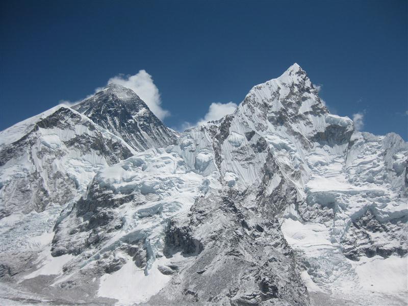
Here is the view from the summit, Mt Everest, 8850m/29,035ft, is on the left, Nuptse 7864m/25,800ft is to the right. I have to chuckle that from here the smaller mountain looks larger and more dramatic than 'the roof of the world', ha... But seriously, could it have been a better view? I think not. Valerie and I sat at the summit, with a rotating cast of probably 20 other hikers, taking pictures and just enjoying the 360 views. (took us just 1:10 to the top)
And of course one of me with the Everest and prayer flags in the background. Cuz you kind of have to take this picture.
We returned to the lodge, running down parts of Kala Patthar actually, which reminded me of the Mt Marathon race back in Alaska, haha. Over lunch I reviewed my initial schedule, and decided it needed modifying. Instead of returning back via the main trail, I'd go with Valerie Over Kongma La, another high mountain pass at 5535m. Can't make things too easy can we? This picture is of course of the 'goodies' counter in the lodge. Yep, if you want to pay for it, you can have beer, Everest whiskey, smokes and candy every day on the trail! I will confess to having my own little bottle of Everest whiskey along, because, why not?
The next morning we woke up and hiked to the very end of the valley, where the Everest Base Camp sits. It was another perfectly clear morning and a wonderful time to be in the mountains. The walk took about an hour and a half, revealing even more spectacular views and this little birdie.
Once you get a little further, up to 5364m, the edges of camp come into view. Suddenly there is a whole multicolored tent city sitting in the end of the valley at the base of a glacier.
Once again you seem to walk with an army of porters and yaks, delivering supplies to base camp.
Wow.
Wandering our way through base camp, we came upon a group doing a ceremony before they left to climb Everest. This was pretty clearly one of the higher end operations, and it showed in their setup. The funny thing is it seemed like they were praying to the company logo on the shrine, “Oh great company, bring me to the top.”
I seeing all these tents and companies, and meeting some of the people “Going to climb Everest” it seems like so much of the adventure is gone. Now if you can pay $65,000, you can hire a company to handhold you all the way to the top requiring almost no skills, it felt a bit too much like an industry to me... Don't get me wrong, it's not like I'd turn it down, or that it's not still impressive to climb, it just left me a little less impressed with the whole climbing Everest thing.
Another shot of what base camp looks like. This is looking back down the valley at Gorakshep.
After wandering between tents, watching people building new tent platforms, porters and yaks unloading and loading, and a quick snack, we walked out onto the glacier that is the approach route to climbing Everest.
One thing I really like about high elevations is the snow and ice formations that occur. This is one of thousands we wandered through in the area. Nature is truly the best artist.
From base camp we had lunch and left Gorakshep, headed back to Lobuche again for the night. The first two lodges we went to were actually full, the first time that had happened to me on the trip. We looked at another, and they had a room but it was $18 for something hardly better than the rooms you pay $1.50 for, or often free once you spend enough on food. We found one that was kind of grubby but had space and was just fine. At the lodge Valerie ran into her guide from the last trek she went on, and I met him and his two clients who were hoping to climb Everest, from India and Japan. That night I stuffed myself on dhal bhat, the classic Nepali dish of rice and lentil soup, and sat among probably 50 people in the lodge that night.
The next morning Valerie and I had another pass to cross, Kongma La, and hit the trail by 6:45am. Yes, another perfectly clear morning, with a light dusting of snow.
The trail took us over the Khumbu Glacier which was quite easy to follow, then on to the slippery rocks of the valley. We slowly climbed our way up the valley into increasingly desolate conditions. Off the main trails finally, there was a three hour period where there wasn't a single other person!
Naturally, clouds had quickly erased the blue skis of the morning, so despite our elevation, there was not much to see. At the pass we met a guide and porter with their somewhat elderly Japanese client, took a few pictures, got some vague directions, and headed down the other side of the pass.
Coming down the other side, we walked between frozen lakes, and back below the snow and rock. We saw a few other people here, but it was mostly porters. The trails were vague, but it was easy going. Uneventful and poor visibility.
We had initially intended on spending the night at Dingboche, but when we got to the intersection between going there and Chhukhung, Chhukhung looked closer and was where Valerie had intended on going anyways so we went there instead.
We had lunch, where I gave myself my only other 'treat' of the trip, a deep-fried Mars candy bar, Valerie and I met Theo, a Quebec, (who gets mad if you call him Canadian, right?!). Partly, I think Valerie just liked talking french again instead of having to speak English with me, haha. Anyways, he was in Chhukhung to climb Island Peak, 6165m, one of the common 'high' peaks for people to climb with a guide. At dinner, Theo and I decided to try and meet up after his climb at Chitwan National Park to do the safari thing together, which ought to be fun.
This evening Valerie asked some advice from another traveler, and came back needing to climb Island Peak for herself. She had managed to get joined along with a group who was doing to climb it shortly, and was very excited about it.
The next morning, we got up early to hike up Chhukhung Ri, 5550m, but were held up a bit by Valeries guide changing plans and going to climb Lobuche East instead. All this talk of climbing one of the higher peaks with a guide was starting to get to me too, but for the first half of the way up I was giving all the reasons for not doing it myself. Really I was just making stupid excuses and being cheap, and by the second half of the climb I had decided I was going to climb a peak, haha.
The clouds had come in naturally, and there was not much to see from the top. We did witness two more big avalanches across the valley that sounded like thunder. This picture is just a clump of different alpine plants in the area. I really enjoy these kind of plants living in such harsh conditions, and these reminded me more of the coral I saw scuba diving in the Philippines than of normal plants!
I wandered around the lodge asking about guides and how to get on a climb from out here, but I got no answers. I decided my best bet would be to return to Namche Bazar to try, since that is the center of activity out here.
Valerie also needed to go to Namche to rent some boots for her climb, so again we set off together down the valley. It was cold and cloudy Chhukhung but in what felt like no time at all, we were out of the snow, out of the cold, into where people even grow crops, and where the sun was shining. It's amazing how quickly things change in the valleys, soon we were back into trees even! The trail itself was pretty but the hiking uneventful. I was surprised how big Dingboche was, without a doubt we were back on the highway, haha.
We ended up stopping at Pangboche for the night, where as the sun set I got this amazing view of Ama Dablam. That evening, I kept on the hunt for a climb, talking to the guide who was with a group at the same lodge, but again it lead nowhere. One guy I met here was an older guy who was in Nepal for his 11th time, seem to be a lot of repeat visitors here.
We had planned an easy day of hiking up the hill above the guest house , then off to Phorche. The clouds had a different plan however, and we both felt tired. Sometimes, if there is no view, what's the point, haha. We went part way up the hillside, watched some kind of antelope like creature on the hill, and turned around. Back in the lodge, I realized it simply didn't make sense to stop at Phorche to meet Tshering Tashi Sherpas parents at their lodge since both Valerie and I had to go to Namche, so the easy day just got a bit longer.
Again, it was shocking how quickly the surroundings change as you drop elevation. Trees, flowers, sun. We were back on the main highway again, stopping for lunch in Tengboche. From there the trail drops down into the bottom of the valley, across a bridge and up the other side to Namche. It turned out to be a longer and more tiring day than expected, for sure.
I just have to say it here. People who hike with iPods really bug me. There, I said it.
We got to Namche Bazar at about 2:45 in the afternoon, on the trail meeting a climbing guide / monk. I forget his name (sorry!) but he was very friendly, chatting about Buddhism and taking us to the monetary, and helped Valerie find some boots to rent. Back in Namche it feels like the big city again, the one good thing about that is food is cheaper! I'd certainly been craving a big meal and not getting it most nights, so Namche was a time to eat like fat kids. Thanks to the market, we got some apples, yak cheese, and chocolate, and I had a big dinner of pasta and Sherpa stew.
At about 11pm, I woke to a slight shaking, my door swinging open (it didn't close well..), and all the dogs barking. Guess it was a tiny earthquake, neat.
In the morning after a very restful night of sleep, it was time to get cracking on some climb business. Valerie needed to go to SPCC to find out if her climbing permit (the biggest cost in a climb) was valid, and I wanted to talk to them about finding a climb to get on, but they were of no help at all... She was worried about her permit, and was trying to find someone to get answers from, but it was just not working. I also was trying to find a way to get on a climb, but it seemed pretty clear at this point it just can't really be done from out here. Valerie got lucky that she was able to, but it didn't work out for me... Eventually she talked to someone who assured her about the permit, and sat down for a snack of bread and cheese.
After the snack, it was time for Valerie to head back up the trail for her climb of Loboche East. Valerie, it was great to hike with you, hope your climb goes well!
I went to the park headquarters that afternoon, which had a museum with a few interesting bits, but spent a boring night a little bummed I wasn't going to be able to do a peak out here...
The next day, I woke up early and on a mission, to get to Lukla, and quickly. Honestly I had no specific need to do this, but at this point the hike was pretty much over. I woke at 6am, felt great, and by 6:45 was tearing up the trail back in my flip flops again! At this time and in this part of the trail, I was just about the only hiker out besides porters, which was nice. I began seeing all the sights I remember from the second day, and Namche to Manjo took me just 1:30. I was in Phakding by 9:45, where someone had told me to have lunch, ha. Morning on the trail was very enjoyable, and it was fun to watch the sun rising in the valley.
As I turned one of the bends, I got this view and knew how close I was to Lukla. Went faster, passing everyone ahead of me, one final push to the end felt good. I arrived by 11:30am, and not knowing how the airline ticketing worked, expecting to have to spend the night in Lukla, I headed straight for the airport.
I walked into the 'office' of the airlines, was told a plane was just on it's way, and that I cold get on that flight. Wow, hadn't expected that! I went out to the runway and the plane arrived less than 5 minutes later. The newcomers were quickly unloaded and we boarded the plane, set for Kathmandu. Even by the time we landed, it had been less than 6 hours since I was in Namche Bazar!
Sharing a taxi with some other returning hikers, I returned to the Thamel area, found a room, took my first shower in two weeks, dropped off my laundry (50 rupees a kg) and set out to find snacks. In the grocery story, I ran into someone from home, Ian Eustis. We used to ski against each other years ago, and he is in Kathmandu teaching music, small world huh? I'm hoping to meet up with him later, since after 8 months he's practically a local now!
That evening I went to Nameste Cafe for dinner and some music. Let me just say it's wonderful to get a tea, delicious burger with fries, and momos for less than a bowl of ramen noodles costs on the Everest trek!
Certainly in my
travels, I've done a lot of great things, no doubt this rates with the best of them. The plan now? I'm a bit up in the air. I've been decompressing here in Kathmandu for a bit, and getting this post written. I hope to meet Theo in Chitwan Park, I want to go to Pokhera. My original idea was renting a scooter and driving myself around for two weeks, but yesterday I learned there is a fuel shortage and you can wait 4 hours for two liters, so that ideas kind of out the window. I am looking into a rafting trip, and maybe some volunteer work as well, but I just don’t' know for now. But, stay tuned, you will find out soon as I do!
Whew, I feel like I just wrote a book, hope it wasn't boring!
Take care, everyone.